 ar
ar bg
bg hr
hr cs
cs da
da nl
nl fi
fi fr
fr de
de el
el hi
hi it
it ko
ko no
no pl
pl pt
pt ro
ro ru
ru es
es sv
sv tl
tl iw
iw id
id lv
lv lt
lt sr
sr sk
sk sl
sl uk
uk vi
vi et
et hu
hu th
th tr
tr fa
fa ms
ms hy
hy ka
ka ur
ur bn
bn mn
mn ta
ta kk
kk uz
uz ku
ku
Inclinometer-based Hydrostatic Leveling System
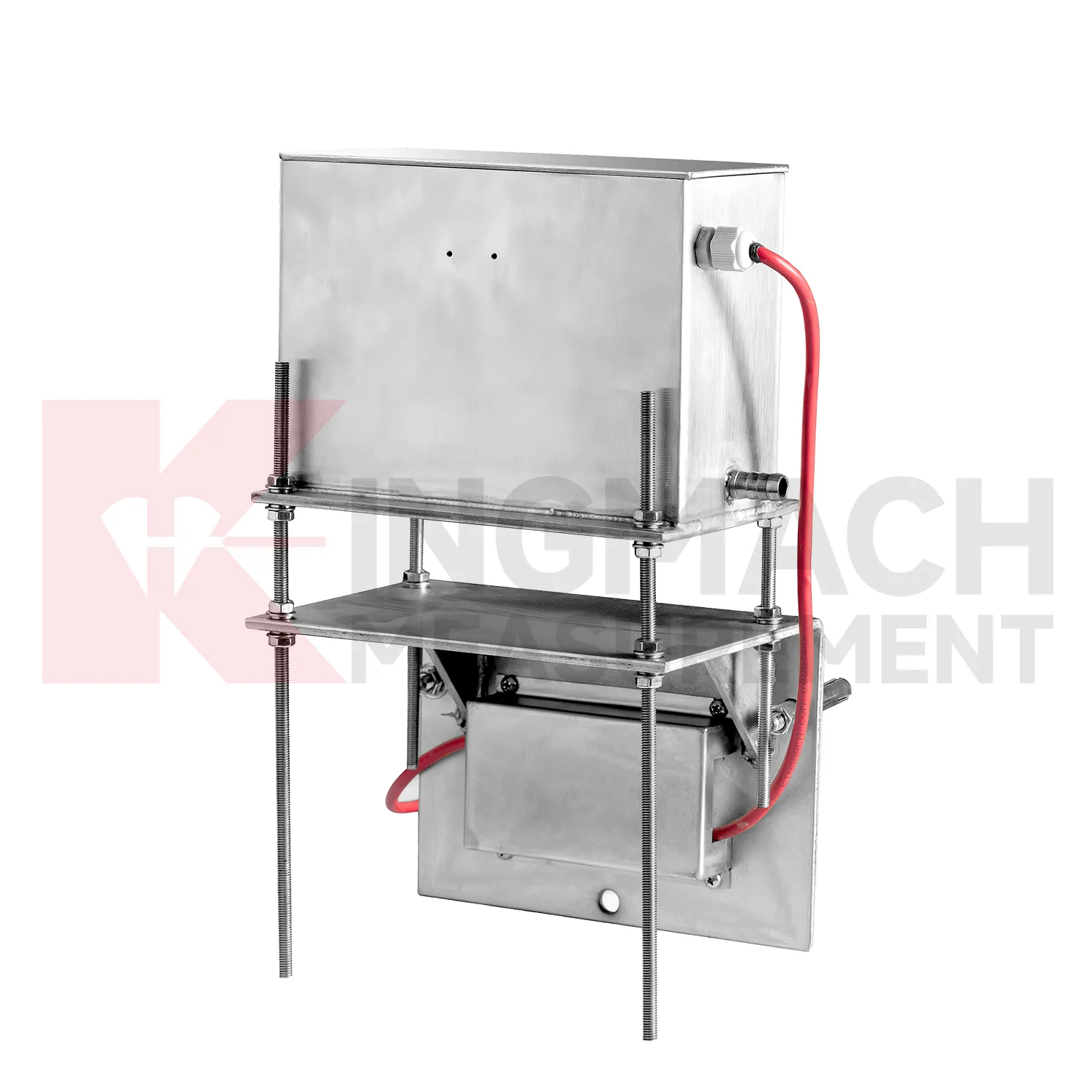
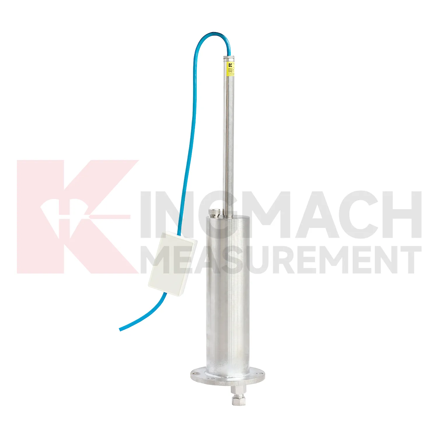
Kingmach Inclinometer-based Hydrostatic Leveling System include the JMDL-47XXAT smart single-point settlement gauge for buried positions where a defined vertical movement must be followed through construction. It is used for subgrade settlement, embankment heave, base uplift in deep foundation pits, tunnel bottom uplift, dyke compression deformation, and pile foundation settlement. Published range options are 100 mm, 200 mm, 300 mm, and 400 mm. Resolution is 0.01 mm on 100 mm and 200 mm models, and 0.1 mm on 300 mm and 400 mm models. Gauge lengths cover 760 mm, 1240 mm, 1720 mm, and 2210 mm. The assembly includes a settlement plate, electrical displacement sensor, measuring rod with metal flexible conduit, anchor head, extension rod, and bottom anchor head. Its side-exit cable design helps reduce interference during pavement compaction. The product is strongest when the installation depth, plate location, cable route, fill layer, and first stable reading are documented before the buried parts disappear under later work.

Application of Inclinometer-based Hydrostatic Leveling System
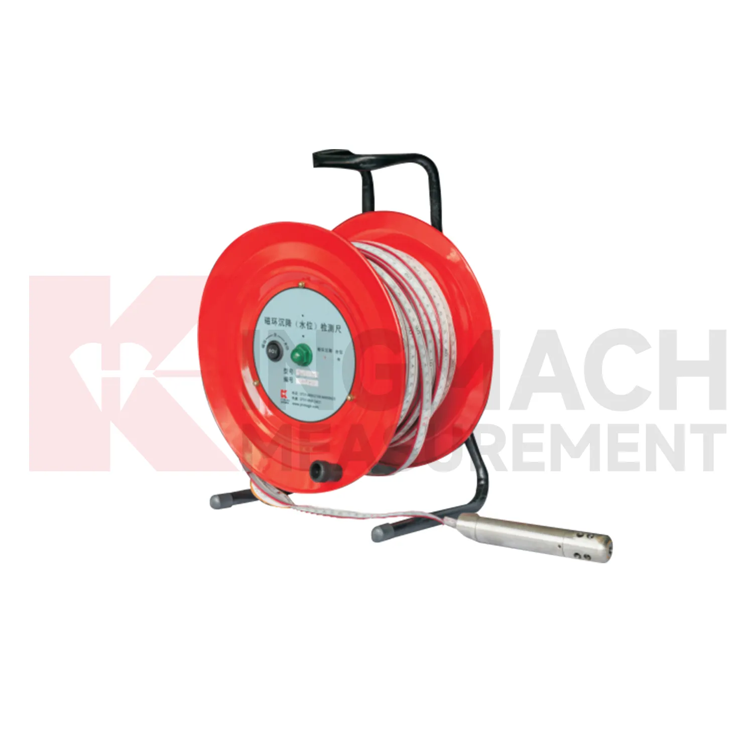
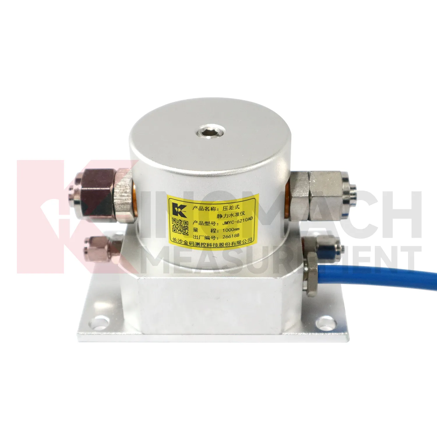
Reclamation and soft ground treatment need Inclinometer-based Hydrostatic Leveling System with enough range to follow large settlement while construction is still changing the load on the ground. In these projects, readings are usually reviewed beside fill height, surcharge placement, drainage progress, vacuum or preload timing, groundwater records, and cross-section drawings. Kingmach JMYC-62XXAD is well matched to this setting because it is a wide-range differential pressure hydrostatic level sensor with 500 mm to 4000 mm range options, 0.1 mm resolution, 0.2%FS accuracy, and RS485 communication. Instead of treating each point as a separate number, engineers can use a reference-point system to see how a whole section is deforming. One area may settle quickly after fill placement, while another reacts more slowly because drainage or soil thickness differs. That profile supports decisions about waiting periods, additional observation, or construction sequencing. The instrument layout should stay clear of heavy vehicle routes, protect cables near temporary roads, and preserve reference stability through the full treatment period.
The future of Inclinometer-based Hydrostatic Leveling System
Future Inclinometer-based Hydrostatic Leveling System will be specified as part of mixed monitoring packages. Settlement alone may show that a point moved downward, but it rarely explains the cause. A railway subgrade package may combine settlement gauges, rainfall, pore pressure, tilt, and vibration. A bridge package may combine hydrostatic settlement, strain gauges, load cells, temperature, and deflection readings. A foundation pit package may combine single-point settlement, groundwater level, retaining wall displacement, and support force. Kingmach already has product groups across settlement, displacement, strain, load, tilt, environmental monitoring, acquisition hardware, cables, and software. The next practical improvement is selecting the settlement product together with the logger, cabinet, communication route, warning levels, and inspection actions. This lets the monitoring network answer a site question instead of producing separate curves that must be interpreted after the fact.
Care & Maintenance of Inclinometer-based Hydrostatic Leveling System
Baseline control for Inclinometer-based Hydrostatic Leveling System is a continuing maintenance task. A zero value should be recorded only after plates, rods, anchors, hydrostatic tubes, reference sensors, magnetic rings, probes, cabinets, and power supply are stable. If the baseline is taken during active compaction, dewatering, grouting, traffic vibration, or support adjustment, every later value may be difficult to explain. Kingmach products can support manual or remote readings, but both methods need a clear starting point. Keep the baseline date, weather, water level, construction stage, operator, and instrument status in the file. If a point must be reset, keep the old value, the new value, and the reason for the change. Do not erase earlier trend data to make a curve look tidy. Future reviewers need to know when the measuring system changed, otherwise normal maintenance can be mistaken for real ground movement.
Kingmach Inclinometer-based Hydrostatic Leveling System
In underground works, Inclinometer-based Hydrostatic Leveling System help separate vertical movement from the noise of excavation, support installation, groundwater, and nearby traffic. Tunnel bottom uplift, subway station settlement, foundation pit base heave, and adjacent ground movement can all affect construction safety. Kingmach JMDL-47XXAT is described for tunnel bottom uplift and base uplift in deep foundation pits, while hydrostatic products can compare several elevations across a station or tunnel section. The monitoring plan should define which reading triggers inspection, who receives the alert, and what nearby data should be checked. Settlement should be reviewed with displacement, support force, water level, tilt, and visual inspection. That wider view keeps a single curve from being overread or ignored. For critical infrastructure, the settlement point should be part of a wider review with displacement, tilt, strain, load, rainfall, and groundwater information. For critical infrastructure, the settlement point should be part of a wider review with displacement, tilt, strain, load, rainfall, and groundwater information.
FAQ
Q: How should Inclinometer-based Hydrostatic Leveling System be maintained?
A: Check reference points, tubes, cables, seals, settlement plates, anchors, probes, cabinets, and channel names at planned intervals.
Q: Should zero values be reset casually?
A: No. A reset can hide real settlement. If a reset is necessary, record the reason, time, old baseline, and new baseline.
Q: What data should be reviewed with settlement?
A: Rainfall, groundwater, excavation depth, filling stage, traffic loading, tilt, displacement, strain, and load data can all help explain settlement changes.
Q: What signs suggest a data issue?
A: Flat lines, sudden jumps after maintenance, impossible values, repeated communication gaps, or disagreement with nearby points may indicate instrument or data-chain problems.
Q: What makes a settlement report useful?
A: A useful report includes point location, model, range, baseline, reference point, latest reading, cumulative settlement, rate of change, and field notes.
Reviews
Ryan Lewis
Fast delivery and excellent product quality. The accelerometers and tiltmeters are highly reliable. Strongly recommend this company.
David Wilson
We purchased displacement transducers and settlement sensors, and the quality exceeded our expectations. Easy installation and reliable performance.
Latest Inquiries
To protect the privacy of our buyers, only public service email domains like Gmail, Yahoo, and MSN will be displayed. Additionally, only a limited portion of the inquiry content will be shown.
Isabella***@gmail.comGermany
Hello, we are evaluating weir flow meters for a water management project. Please share accuracy deta...
Harper***@gmail.comIndia
Dear Sir, we are planning to procure a complete monitoring system including strain gauges, tiltmeter...